A GIS layer on the Integrity website exists detailing the Agricultural Land Grades under RsMo. 137.021 for Phelps County Parcels.
Instructional Steps:
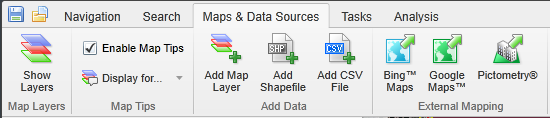
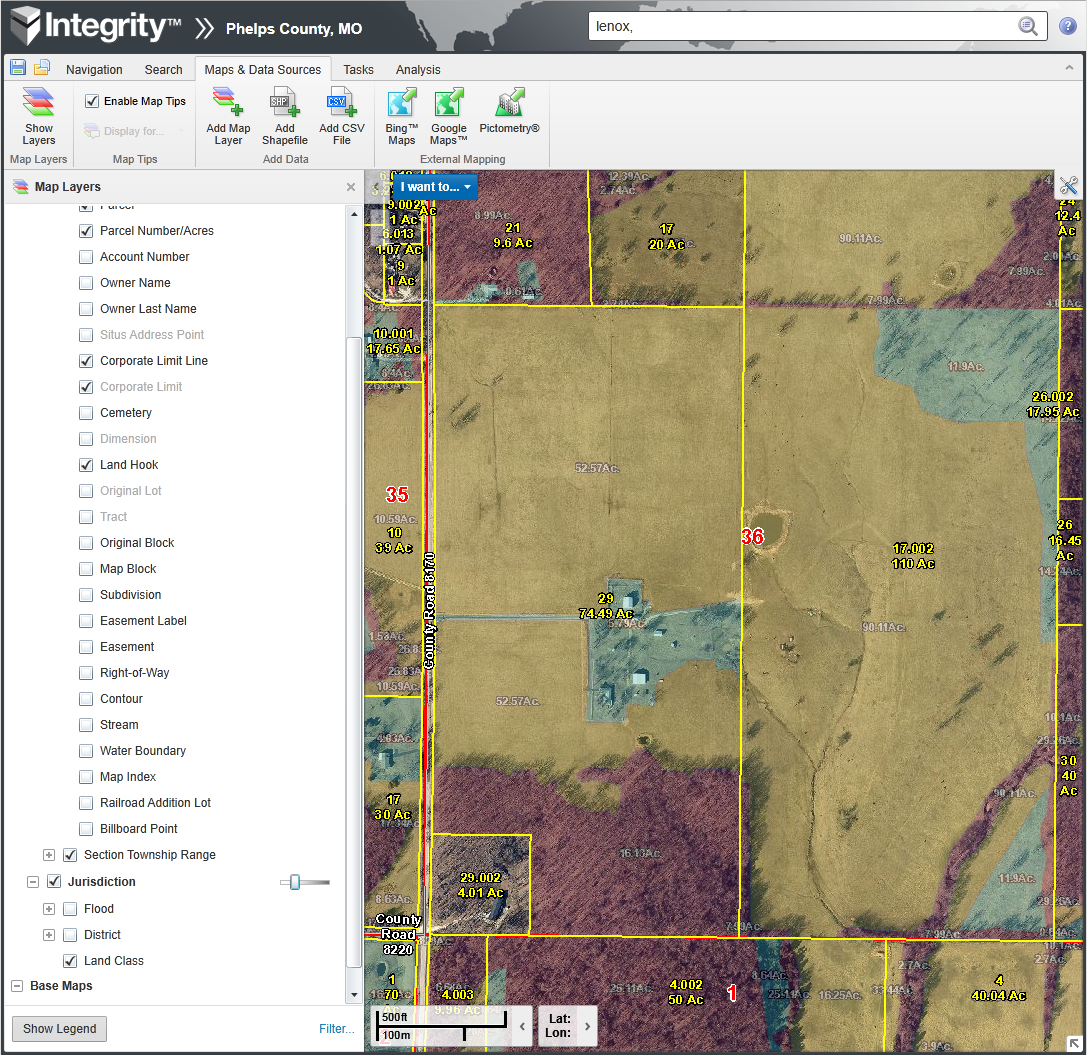
You can turn on our “Land Class” layer by selecting the  button on the “Maps & Data Sources” tab.
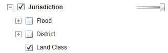
Then turn on the layer by making sure the checkbox is checked next to “Land Class” in the “Jurisdiction” sub-group under “Operational Layers”
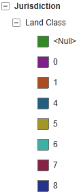
The layer will initially appear opaque and will use the following color key (which can be accessed by clicking the  button at the bottom of the “Map Layers” sidebar).
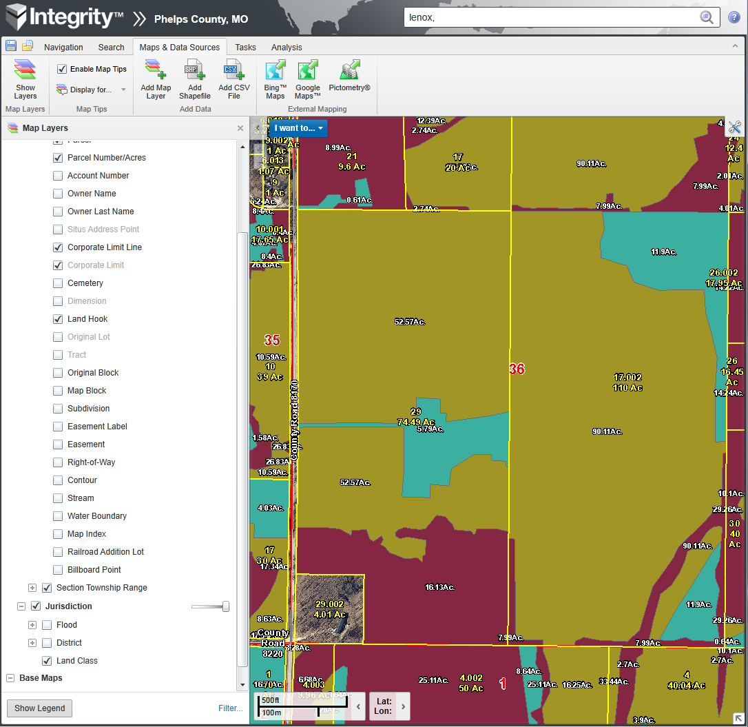
The transparency of the layer can be adjusted using the  located to the right of “Jurisdiction” on the “Map Layers” sidebar to allow you to see the underlying parcel.
Agricultural/Horticultural Land Grades
The following are definitions of the agricultural and horticultural eight (8) grades as published by the State Tax Commission.
GRADE 1: This is prime agricultural land. The condition of the soils is highly favorable with no limitations that restrict their use. Soils are deep, nearly level (zero to two percent (0-2%) slope), or gently sloping with low erosion hazard and not subject to damaging overflow. Soils that are consistently wet and poorly drained are not placed in Grade 1. They are easily worked and produce dependable crop yields with ordinary management practices to maintain productivity - both soil fertility and soil structure. They are adapted to a wide variety of crops and suited for intensive cropping. PI Range: 93-100
GRADE 2: These soils are less desirable in one (1) or more respects than Grade 1 and require careful soil management, including some conservation practices on uplands to prevent deterioration. This grade has a wide range of soils and minimum slopes (mostly zero to five percent (0-5%)) that result in less choice of either crops or management practices. Primarily bottomland and best upland soils. Limitations: Low to moderate susceptibility to erosion; Rare damaging overflows (once in five to ten (5-10) years); and Wetness correctable by drainage. PI Range: 86-92
GRADE 3: Soils have more restrictions than Grade 2. They require good management for best results. Conservation practices are generally more difficult to apply and maintain. Primarily good upland and some bottomland with medium productivity. Limitations: Gentle slope (two to seven percent (2-7%)); Moderate susceptibility to erosion; Occasional damaging overflow (once in three to five (3-5) years) of Grades 1 and 2 bottomland; and Some bottomland soils have slow permeability and/or poor drainage. PI Range: 76-85
GRADE 4: Soils have moderate limitations to cropping that generally require good conservation practices. Crop rotation normally includes some small grain (for example, wheat or oats) and/or hay. Soils have moderately rolling slopes and show evidence of serious erosion. Limitations: Moderate slope (four to ten percent (4-10%)); Grade 1 bottomland subject to frequent damaging flooding (more often than once in two (2) years), or Grades 2 and 3 bottomland subject to occasional damaging flooding (once every three to five (3-5) years); Poor drainage in some cases; and Shallow soils, possibly with claypan or hardpan. PI Range: 66-75
GRADE 5: Soils are not suited to continuous cultivation. Crop rotations contain increasing proportions of small grain (for example, wheat or oats) and/or hay. Upland soils have moderate to steep slopes and require conservation practices. Limitations: Moderate to steep slopes (eight to twenty percent (8-20%)); Grades 2 and 3 bottomland subject to frequent damaging flooding (more than once in two (2) years) and Grade 4 bottomland subject to occasional damaging flooding; and Serious drainage problems for some soils. PI Range: 56-65
GRADE 6: Soils are generally unsuited for cultivation and are limited largely to pasture and sparse woodland. Limitations: Moderate to steep slopes (eight to twenty percent (8-20%)); Severe erosion hazards present; Grades 3 and 4 bottomland subject to frequent damaging flooding (more than once in two (2) years), and Grade 5 bottomland subject to occasional damaging flooding (once every three to five (3-5) years); and Requires intensive management for crops. PI Range: 40-55
GRADE 7: These soils are generally unsuited for cultivation and may have other severe limitations for grazing and forestry that cannot be corrected. Limitation: Very steep slopes (over fifteen percent (15%)); Severe erosion potential; Grades 5 and 6 bottomland subject to frequent damaging flooding (more than once in two (2) years); Requires intensive management to achieve grass or timber production; and Very shallow topsoil. PI Range: 15-39
GRADE 8: Land capable of only limited production of plant growth. It may be extremely dry, rough, steep, stony, sandy, wet or severely eroded. Includes rivers, running branches, dry creek and swamp areas. Such lands do provide areas of benefit for wildlife or recreational purposes. PI Range: 0-14
Productivity Index Rating (PI)
The Productivity Index (P.I.) provides a scientific basis for comparing one soil with another soil. These P.I.’s should remain constant over a period of years while overall yields may increase. For our use, we will use the Production Index system developed by Ival D. Persinger, who was a Soil Scientist for the Soil Conservation Service, Columbia, Missouri. This system has been revised and updated by the Soil Conservation Service to consider current technology and trends. More detailed information about this method can be obtained at local Soil Conservation offices statewide.
Calculation of P.I.’s involve indexing soils and assigning a value (zero or minus) to each subdivision of the soil property or factor. These details will not be explained here; but contact with local Soil Conservation Service offices will yield information as to the calculation of P.I.’s. An individual P.I. rating for a soil mapping unit reflects the integrated effect of numerous factors that influence the yield potential.
The six soil properties considered for the P.I. system are: (1) Nutrient supplying power; (2) Depth of root penetration; (3) Natural soil drainage; (4) Soil texture; (5) Flooding and ponding; and (6)Slope and erosion.
These P.I.’s can also be used as another tool to assist the appraiser/assessor in selecting the appropriate land grade for agricultural and horticultural lands.
I hope this helps! More can be learned by visiting Section 7.3 AG LAND VALUATION of the Assessor’s Manual as promulgated by the State Tax Commission at http://stc.mo.gov/files/073_CHAPTER7.3AGLAND.pdf.